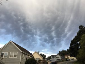
Peggy Berryhill noticed these unusual clouds a few weeks ago. Scott Gasparian identified them as mammatus clouds, often a predictor of wild weather.
 Scott wrote, "When I used to fly paragliders cross county, I found there are two sizes of clouds: those that are small and fed by an updraft, and those that get big enough to internally generate lift. We refer to the second type as 'cloud suck.'
"The normally flat bottom of the cloud starts to dome upwards as the freezing/cooling water in the clouds starts to accelerate. When the vertical column reaches up far enough to get into the really cold air zone, then we get hail, and thunder and lightning.
"If it keeps getting higher, with enough warm wet air to feed into it, tornadoes and waterspouts can spawn. If you see mammatus, and they start to rotate, duck. If moving away from you and rotating, sound the alarm. I lived in flat Missouri for a while and have seen two tornado starts, and a bunch of almosts, scary thrilling power to behold."
We Mendonomans will stick to a little hail and lightning, thank you very much.
Thanks to Peggy for allowing me to share her photo with you here, and thanks to Scott for teaching us about mammatus clouds.
