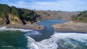
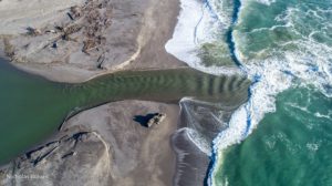
Nicholas Wilson wrote, "The Navarro River mouth sandbar finally breached naturally early Monday Jan. 8, 2018, letting backed-up river water flow into the Pacific, and allowing reopening of Hwy. 128. Due to continued wet weather through the week, today Friday the 12th was the first chance I had to get aerial photos of the new channel through the sandbar. Here are two views taken with a DJI Phantom 4 Advanced flying camera. It was low tide, with a strong current flowing out through the new channel. The lower five miles or so of the river is a tidal estuary, with sea water flowing in through the channel during high tide.

 How wonderful to see this river from the air! We are all glad it opened, as did the Gualala River. When the Navarro backs up, it can flood Highway 128. The Gualala River doesn't have development in its floodplain, and consequently causes no problems when it floods.
Thanks to Nicholas for these great photos. If you'd like to connect with him, here is a link to his Facebook page: https://www.facebook.com/nicholas.wilson.3975
