Autumn is a favorite time of year for many of us. A storm system with no rain moved across the Mendonoma Coast a week ago Saturday, blowing needles off trees and scattering them seemingly everywhere. The color of the sunlight has already changed to a warmer gold.
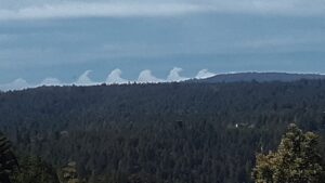
That windy weather brought a sighting of rare Kelvin-Helmholtz cloud waves, seen by Jane Simmonds. She wrote, “Looking west from our home in Annapolis on Sunday, September 15th, I saw what seems to be the fog rising in peaks and then curling a bit like a wave breaking. First time I've ever seen that.”
Kelvin-Helmholtz cloud waves form on windy days, when two different layers of air move at different speeds. The winds in the upper layer move at a higher speed and cause tops of the clouds to roll over, just like a breaking wave.clo
Jane’s sighting had me wondering about the difference between fog and clouds. I learned there is no difference other than altitude. Fog is defined as a visible moisture that begins at a height lower than 50 feet. If the visible moisture begins at or above 50 feet, it is called a cloud.
Thanks to Jane for allowing me to share her photo with you here.
Foggy at the coast today, sunny at Rick's and my place in Anchor Bay. Temps mild, in the mid-sixties.

